

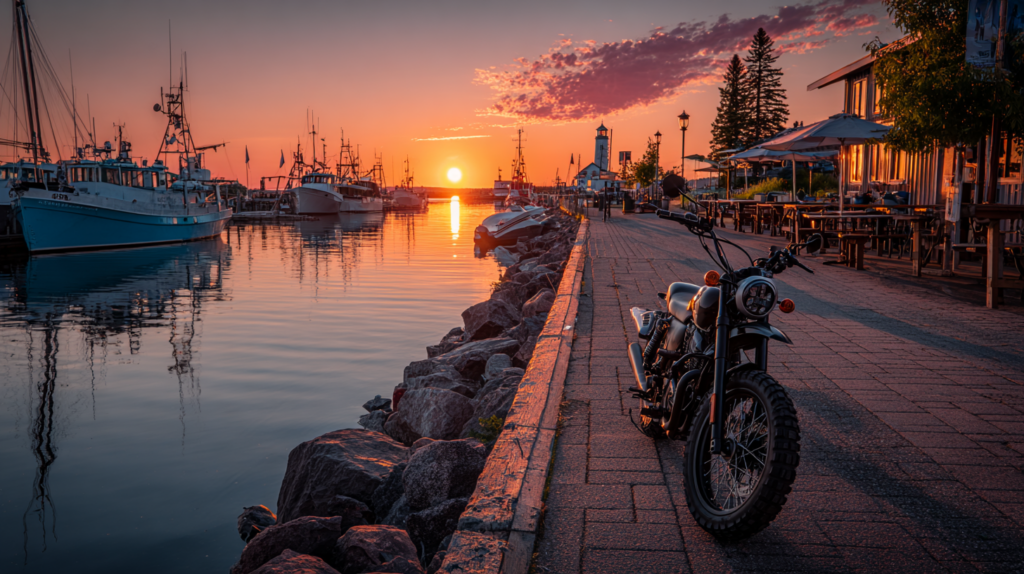
You can ride the full Lake Superior Circle Tour in about 1,300 miles (2,000 km) of open road through Michigan, Wisconsin, Minnesota, and Ontario. This route gives you sweeping lake views, quiet coastal highways, and a mix of small towns and outdoor stops that make it one of North America’s best motorcycle journeys.
Plan fuel and border crossings, pick key stops for scenic overlooks and food, and pack gear for changing weather so you stay safe and comfortable. Expect stretches of remote road and big scenery that reward a steady pace and simple planning.
Key Takeaways
- Ride the full circle to see the lake’s best coastal views.
- Prepare for border checks, fuel gaps, and shifting weather.
- Choose a few key stops and safe overnight spots to enjoy the trip.
Planning Your Lake Superior Motorcycle Adventure
You will pick a start point, choose the best season, and plan time and mileage based on how much of the loop you want to ride. Focus on fuel stops, border crossings, and weather when you map your days.
Best Starting Points
Pick a start that fits your travel logistics and fuel range. Duluth, MN is convenient if you fly in; it has major services, rental choices, and easy highway access to the North Shore. Thunder Bay, ON works well if you want long northern stretches and fewer border crossings. Sault Ste. Marie sits on the eastern side and gives you quick access to Ontario’s scenic coast and Canadian services.
If you want Minnesota’s Lake Superior views first, start in Duluth and head north. For a mostly Canadian loop, begin in Thunder Bay or Sault Ste. Marie. Check fuel spacing: remote northern stretches can be 100–200 miles between stations. Carry a basic tool kit, extra fuel if your range is tight, and your passport for border crossings.
Ideal Travel Seasons
Late June through early September offers the most reliable weather and open roads. Summer months mean warmer temperatures, longer daylight, and more motel and campground options. Expect daytime highs from the 60s to 80s °F (15–30 °C) and cooler nights.
Shoulder seasons (May–June, September) give fewer crowds and lower rates but bring unpredictable rain, cooler temps, and some services that open later. Winter and early spring are not suitable for most motorcycles because of snow, ice, and closed tourist services. Always check local forecasts and lake-effect weather before each riding day.
Route Duration and Distance
The full paved circle runs about 1,300 miles (2,000 km). Plan riding days by your comfort: 3–4 days will be very long daily rides, 7–10 days lets you enjoy stops, and 10–14 days gives a relaxed pace with sight-seeing.
Use this rough daily plan:
- 3–4 days: 300–450 miles per day — for experienced riders only.
- 7–10 days: 130–200 miles per day — comfortable sightseeing.
- 10–14 days: 80–130 miles per day — relaxed pace with side trips.
Factor in rest days, ferry or border delays, and lower speeds on winding coastal roads. Mark fuel, food, and lodging options every 100–150 miles to avoid long detours.
Classic Lake Superior Circle Route Overview
You will ride about 1,300 miles (2,092 km) around Lake Superior, crossing three U.S. states and one Canadian province. Plan fuel stops, border documents, and a mix of paved scenic roads and stretches with few services.
Primary Highways and Roads
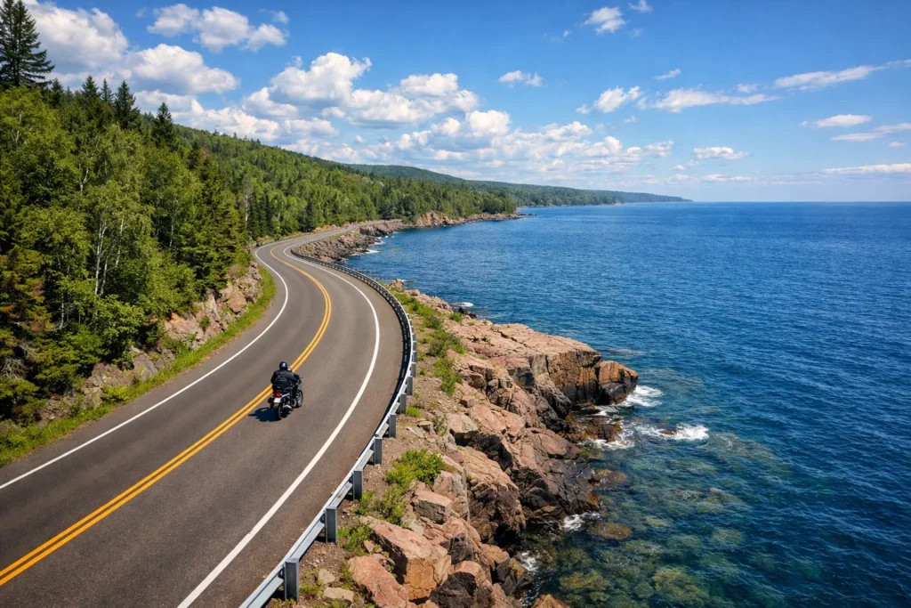
The loop uses specific highways in each region. In Minnesota, the North Shore follows Highway 61 from Duluth to Grand Marais. This road hugs the lake and has many state parks and pullouts.
In Wisconsin and Michigan, you’ll use US-2 across the western and central Upper Peninsula and M-28 toward the north shore towns. Expect long rural stretches with fewer services.
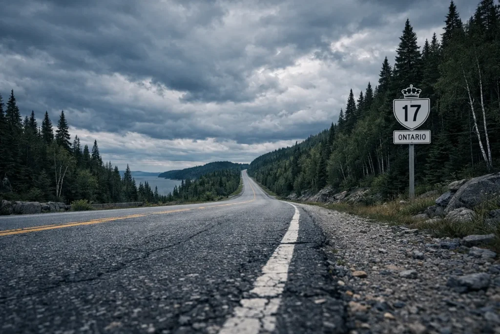
In Ontario, the main corridor is the Trans-Canada Highway (Highway 17) along the lake’s northern shore, plus Highway 11/17 transitions east and west. Road surfaces are mostly paved; watch for construction and variable shoulder width.
Table — Key road segments
| Region | Primary Highway | Typical Conditions |
|---|---|---|
| Minnesota North Shore | Hwy 61 | Scenic, twisty, frequent services |
| Wisconsin Coast | US-2 / County roads | Rural, mixed pavement |
| Michigan U.P. | US-2, M-28 | Long distances, fewer towns |
| Ontario North Shore | Hwy 17 (TCH) | Long stretches, small towns |
Route Navigation Tips
You must mark fuel stops and nightly stops before you leave. Fuel can be scarce between towns, especially in northern Ontario and parts of Michigan. Carry a charged phone, paper maps, and a GPS track.
Plan daily distances around 150–300 miles depending on stops and road speed. Check weather reports; fog and wind off the lake can slow you. Set alerts for construction and seasonal closures.
Border crossings need passports and proof of vehicle ownership. Bring cash or cards for fuel, small repairs, and ferry or park fees. Consider a route app that supports offline maps.
Major Border Crossings
You will cross the US–Canada border at several possible points. Common crossings on the route include:
- Sault Ste. Marie (I-75/Highway 17) — major, open 24/7, good services.
- Pointe aux Pins / White River area crossings — smaller, check hours.
- International Bridge at Sault Ste. Marie table below shows details.
Border crossings table
| Crossing | Location | Notes |
|---|---|---|
| Sault Ste. Marie | ON/MI | 24-hour, passport control, nearby services |
| Pigeon River / Thunder Bay area | ON/MN-MI approaches | Seasonal hours possible |
| Other small crossings | Various | Check CBP/CBSA hours before travel |
Carry your passport, vehicle registration, and insurance card. Declare goods honestly and check for temporary import rules for vehicles. Expect short waits at major crossings in summer; smaller crossings may close overnight.
Highlight Stops and Scenic Views
Expect towering cliffs, wide sandy beaches, and small towns with food and fuel. You’ll find dramatic vistas, easy pull-offs, and several places to stretch your legs and take pictures.
Must-See Natural Attractions
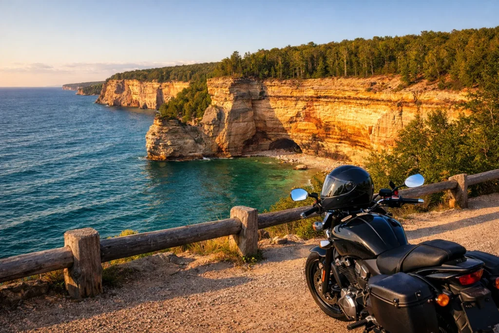
Pictured Rocks National Lakeshore in Michigan gives you colorful sandstone cliffs and waterfalls right off the road. Park at Miner’s Beach or Miners Castle for short walks and photo spots.
Apostle Islands, off Wisconsin, offer sea caves you can view from a kayak in summer or on ice in winter; check the National Park Service site for conditions (https://www.nps.gov).
On the Ontario side, Lake Superior Provincial Park has beaches, hiking trails, and the Agawa Rock petroglyphs. Plan for dirt roads inside the park and limited services, so carry water and a basic tool kit.
Near Thunder Bay, Sleeping Giant Provincial Park forms a distinct silhouette on clear days. Each of these stops has easy access from the Circle Tour route and rewards you with short hikes or viewpoints without long detours.
Best Lookout Points
The North Shore’s Highway 61 in Minnesota offers several scenic pullouts; Palisade Head provides a high cliff view over clear water and is only a short climb from the parking lot.
On Michigan’s Upper Peninsula, Munising overlooks and the Pictured Rocks boat tours show the shoreline from different angles, useful if you want photos from water level. Book tours ahead in peak season.
In Ontario, the Terry Fox Memorial near Thunder Bay sits on high ground with broad lake views. For wide-angle shots at golden hour, aim for sunrise at these spots.
Carry binoculars and a windproof layer; viewpoints can be windy and cool even in summer.
Quaint Towns Along the Way
Grand Marais, Minnesota, sits on a protected harbor with art shops, good coffee, and a dependable gas stop. It’s a practical overnight choice with cozy motels and bike-friendly eateries.
Marquette, Michigan, has a rebuilt downtown and several dining options. It also serves as a gateway to inland trails if you want a short gravel detour.
On the Canadian leg, Wawa and Nipigon offer classic roadside services and local diners; Wawa’s giant goose statue makes an easy landmark for meeting points. For road and border info, consult provincial travel sites like Ontario Travel (https://www.ontario.ca).
Each town provides fuel, basic repairs, and places to rest, so plan fuel stops about every 100–150 miles depending on your bike.
Motorcycle-Friendly Accommodations
You will find places that welcome bikes, offer secure parking, and sit close to the main route. Options range from inns with covered parking to state parks with bike-friendly campsites.
Recommended Lodging Options
Look for motels and small inns in towns like Ashland, Marquette, and Sault Ste. Marie that advertise covered or monitored motorcycle parking. Choose places with ground-floor rooms or easy access to unload gear. Many lodges on the North Shore (for example near Lutsen and Grand Marais) cater to riders with heated garages or tools for minor repairs.
Check booking notes for motorcycle groups or luggage storage. Ask about nearby gas and repair shops so you don’t get stuck early in the morning. If you ride into Canada, confirm border-crossing hours and ID requirements with the hotel before you book.
Camping Sites for Riders
State and provincial parks along the route offer campsites a short ride from the lake. Brimley State Park (MI) and sites near Porcupine Mountains give easy access to scenic roads and have vehicle-accessible sites for trailers or large rigs. Look for sites with paved or gravel pull-throughs to park beside your tent or bike.
Use park maps to pick sites close to restrooms and showers. Reserve early in summer and check fuel and food availability near the campground. Carry a basic lock and cover; unsecured gear and exposed bikes attract attention.
Essential Gear and Motorcycle Preparation
Pack clothing that handles cold winds, rain, and sunny stretches. Prepare the bike so brakes, tires, and lights work well for long rural highways and remote fuel stops.
Weather-Appropriate Clothing
Choose a layered system: a moisture-wicking base layer, an insulating mid-layer, and a waterproof outer shell. Bring a breathable waterproof jacket and pants with taped seams; rain can arrive fast along Lake Superior.
Use a full-face helmet with a clear and tinted insert or a drop-down sun visor for changing light. Carry heated grips or a plug-in heated liner if you get cold easily. Bring waterproof gloves and a thin pair for warmer days.
Pack one warm hat for stops and a neck gaiter to block wind. Bring two pairs of socks—one wool or synthetic for cold, one lighter for warmth. Store wet items in a waterproof dry bag so the rest of your gear stays dry.
Maintenance Checks Before Departure
Start with tire inspection: check tread depth, look for cuts or bulges, and set cold tire pressure to the manufacturer’s spec. Carry a compact tire repair kit and a portable inflator rated for motorcycle tires.
Check brake pads and fluid levels. Squeeze the brake lever and pedal to feel for firm pressure and no sponginess. Replace pads if less than 2–3 mm of lining remains.
Inspect chain or shaft drive: clean, lubricate, and set proper chain slack. Verify sprocket teeth for wear. Tighten axle nuts to spec.
Test lights, signals, horn, and charging system. Confirm the battery holds charge and terminals are clean. Pack basic tools, spare fuses, a spare bulb, and a small first-aid kit.
Safety Considerations on the Lake Superior Route
Expect changing pavement, long distances between services, and frequent wildlife crossings. Carry basic tools, a charged phone, and plan fuel stops to match the longest gaps on your chosen daily leg.
Road Conditions and Hazards
Road surfaces vary from smooth two-lane highways to cracked rural pavement and short gravel shoulders. Watch for frost heaves, potholes, and loose gravel at bridge approaches and in shaded corners.
Weather can shift quickly near the lake. Rain reduces traction and visibility; strong crosswinds can push a tall windshield or trailer. Check local DOT sites or park road reports each morning. Pack a basic tire repair kit, a spare tube or plug kit, and an air pump. Ride at a speed that lets you stop within your sight distance and avoid sudden lane changes.
Plan fuel and food stops. Some stretches, especially in northern Ontario and Minnesota, have 60–150 miles between stations. Note mileage between towns on your route map and top off when you can. Carry a small first-aid kit and high-visibility vest for roadside work.
Wildlife Awareness
Wildlife crossings are common, especially at dawn and dusk. Deer, moose, and bears can appear suddenly from tree lines close to the road. Moose are especially dangerous: they are heavy, hold position, and cause severe impact damage.
Use higher vigilance near water, wetlands, and forest edges. Slow your speed in posted animal-crossing zones and in low-light conditions. Scan both sides of the road and reduce speed where vegetation blocks sightlines.
If an animal appears, brake firmly and stay in your lane. Swerving often causes worse outcomes. If you must leave the road to avoid a collision, try to slow first and then steer gradually. After any wildlife strike or near-miss, stop safely, check yourself and the bike, and report large-animal strikes to local authorities.
Cultural and Culinary Experiences
You will find lively local festivals, historic events, and food traditions tied to fishing, mining, and Indigenous cultures. Expect fresh lake fish, wild rice dishes, berry desserts, and regional brewing and distilling scenes.
Local Events and Festivals
Plan your trip around dates if you want to join community gatherings. In Duluth, Minnesota, you can hit the annual Grand Day Parade and Canal Park festivals in summer. Marquette, Michigan hosts the Ore to Shore mountain bike race and the UP Mine Rescue contest, both tied to regional heritage.
In Thunder Bay and Sault Ste. Marie, look for powwows and Indigenous cultural events that showcase drumming, dance, and craft vendors. Small towns like Grand Marais and Bayfield stage art fairs and harbor festivals with live music and local vendors. Check municipal calendars for exact dates and any border-crossing rules if you’ll ride into Ontario.
Regional Foods to Try
Taste fresh lake trout or whitefish smoked by local smokehouses along the north shore. Order a fish fry in Wisconsin or Michigan — it’s often beer-battered perch or walleye served with coleslaw and fries.
Sample Indigenous foods such as wild rice pilaf, bannock, and berry preserves made from local blueberries or raspberries. Stop at roadside bakeries for sugar pie in Ontario or pasties (meat and potato hand pies) in the Upper Peninsula — a legacy of mining communities. Also try regional craft beers, ciders, and small-batch spirits available at pubs and distilleries in port towns.
FAQS
How long is the route?
The full Lake Superior Circle Tour is about 1,300 miles. You can shorten it by picking only the north shore or a single state/province section.
How many days should you plan?
Aim for 5–10 days depending on your pace. Faster riders may do it in 4 days, but 7–8 days gives time for sights and rest.
What roads will you ride?
You will use state and provincial highways through Michigan, Wisconsin, Minnesota, and Ontario. Road quality is generally good, but watch for construction and rural stretches with fewer services.
Do you need a passport?
Yes, you need a passport or other accepted travel ID to cross into Canada. Check current border rules before you leave.
Where do you fuel and find food?
Fuel and food are common in towns, but distances between services can be long on some shores. Plan fuel stops and carry snacks and water for remote stretches.
What weather should you expect?
Weather can change fast. Summers are typically mild, but you can still get rain and cool nights. Layer your gear and check forecasts daily.
Are there must-see stops?
You choose the highlights: state parks, waterfalls, lighthouses, and coastal overlooks. Pick a few key stops so you have time to enjoy them.
Is this ride suitable for beginners?
Parts are beginner-friendly, but long miles, variable weather, and remote segments make this better for riders with some touring experience.
Conclusion
You can ride the Lake Superior route as a long loop or in shorter segments. Plan fuel, border crossings, and daily distances before you leave to keep the trip smooth.
Expect varied scenery: cliffside views, quiet towns, and long stretches of shoreline. Weather can change quickly, so pack layers and check forecasts often.
Take time for stops. Short detours to parks, lighthouses, and local diners add value without adding much time. Riding at a steady, comfortable pace helps you notice more and ride safer.
If you cross between the U.S. and Canada, bring your passport and any required documents. Mark fuel and food stops on your map, especially on remote stretches where services are sparse.
Ride within your skill and comfort level. Road surfaces, wind, and wildlife can affect conditions, so stay alert and adjust speed as needed.
Use this route as a framework, not a rule. Customize daily mileage, sights, and rest days to match what you enjoy most. The route rewards riders who prepare, stay flexible, and take in the views.